February 2002
Intermediate to advanced
720 pages
21h 37m
English
You want to display a map and allow users to click on regions of the map. You want the form to react based on which region is clicked on. The regions aren’t necessarily rectangular. How can you do this?
You can accomplish this task using a combination of bitmaps and transparent command buttons. Depending on how far from rectangular your shapes are, this task may be trivial or quite involved. By making the command buttons transparent, you make the application appear to react directly to mouse clicks on the map.
Open frmWesternUS in
09-03.MDB (Figure 9-7). This
form has been created with an imported bitmap file as the background.
Above each state’s image on the map there’s at least one
command button with its Transparent property set to Yes. Figure 9-8 shows the form named frmWesternUSDesign, in
which the buttons are not transparent. Here you can see the actual
layout of the command buttons.
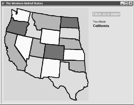
Figure 9-7. The finished map form, frmWesternUS, with transparent buttons
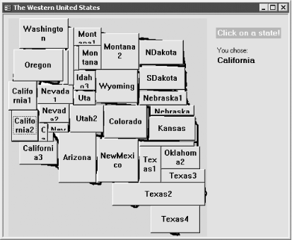
Figure 9-8. The same bitmap form with buttons showing
To implement similar functionality in your own forms, follow these steps:
Create a new form. Click anywhere in the detail section of the form, and select Insert → Object (or use the form design toolbox to place an unbound ...
Read now
Unlock full access


 O’Reilly covers everything we've got, with content to help us build a world-class technology community, upgrade the capabilities and competencies of our teams, and improve overall team performance as well as their engagement.I wanted to learn C and C++, but it didn't click for me until I picked up an O'Reilly book. When I went on the O’Reilly platform, I was astonished to find all the books there, plus live events and sandboxes so you could play around with the technology.I’ve been on the O’Reilly platform for more than eight years. I use a couple of learning platforms, but I'm on O'Reilly more than anybody else. When you're there, you start learning. I'm never disappointed.I'm always learning. So when I got on to O'Reilly, I was like a kid in a candy store. There are playlists. There are answers. There's on-demand training. It's worth its weight in gold, in terms of what it allows me to do.