Rasters with Integer Cell Values
Rasters with integer cell values are used to store what is variously called discrete data or categorical data. Such data sets describe a phenomenon or object that exists at the location of that cell, referenced by the cell Value.
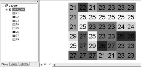
Each cell in an integer raster belongs to a zone. The zone number—the Value—must be an integer—positive, negative, or zero. Cells in a given raster that have the same value all belong to the same zone. So a zone consists of all the cells with a given value. Each cell that has a Value belongs to some zone or other, even if the zone is composed of only one cell. Cells in a zone may be adjacent, but may well not be. See Figure 8-2.
FIGURE 8-2 Basic_Raster with integer values indicating categories
An integer raster has associated with it a Value Attribute Table (VAT).4 The table may have many fields but the two primary fields are Value and Count.
There is a record in the VAT for each zone. The raster shown in Figure 8-2, consists of eight zones. The zone numbers are 21, 22, 23, 24, 25, 26, 27, and 29. Obviously, sets of cells in the same zone may be connected or not.
The raster shown Figure 8-2, which we will call Basic_Raster, would have a VAT as shown in Figure 8-3. It indicates, for example, that Zone 21 consists of six cells. Figure 8-2 shows you that the cells with value 21 are not all connected.
FIGURE 8-3 Basic_Raster ...
Get Introducing Geographic Information Systems with ArcGIS: A Workbook Approach to Learning GIS, 3rd Edition now with the O’Reilly learning platform.
O’Reilly members experience books, live events, courses curated by job role, and more from O’Reilly and nearly 200 top publishers.

