Euclidean Distance and the Spatial Analyst
Proximity, the closeness of one point in space to another, is most easily expressed by the Euclidean straight-line distance between the two points. The term “Euclidean” comes from the geometry that was first formally developed by Euclid around 300 BCE.
ArcGIS Spatial Analyst allows you to automatically make a raster in which each cell in the raster contains the straight-line distance from itself to the closest cell of a set of source cells in another raster that represents the same geographic space. (Actually, because this distance is represented on the two-dimensional raster surface—differences in elevation being excluded—we could refer to the values in the cells as “Cartesian distance” after the mathematician Descartes.
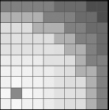
Figure 8-12 shows a raster whose cells are composed of Euclidean distances from each cell to the dark cell in the lower left. The lighter the color, the smaller the distance.
Get Introducing Geographic Information Systems with ArcGIS: A Workbook Approach to Learning GIS, 3rd Edition now with the O’Reilly learning platform.
O’Reilly members experience books, live events, courses curated by job role, and more from O’Reilly and nearly 200 top publishers.


