Digital Orthophotos
A digital orthophoto is an aerial photograph that has been rectified (adjusted) so that it may be used as a map with (an almost) constant scale throughout. (Fixing aerial photos so that they become orthophotos is a complicated process, beyond the scope of this book. Consult remote sensing texts or the Internet if you are interested.)
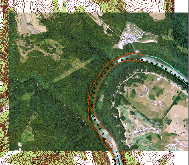
____ 21. Add a layer from an orthophoto “TIF” file: Zoom to the GPS track. Navigate to [___]IGIS-Arc\River and add a layer to the map based on COLE_DOQ.TIF. (Ignore any warnings about projecting layers. If asked, do not build pyramids.) If necessary, drag the COLE_DOQ title next to the bottom of the T/C (with only the DRG layer below it). Zoom to the extent of the orthophoto image layer. See Figure 2-27. You can get an interesting perspective on the images by flipping COLE_DOQ.TIF off and on. Notice the water filtration plant and other artifacts on both the DRG and the DOQ. Zoom up on the area of the island. Observe that you see the island on the DRG (and see it outlined by vectors) but on the DOQ the island has disappeared. It may well have been under water at the time this photo was taken. A 20-foot rise in water level on this river during floods is not uncommon.
____ 22. Experiment with different levels of magnification on the DOQ. Notice that when you are zoomed in very tightly, the “meaning” contained in the ...
Get Introducing Geographic Information Systems with ArcGIS: A Workbook Approach to Learning GIS, 3rd Edition now with the O’Reilly learning platform.
O’Reilly members experience books, live events, courses curated by job role, and more from O’Reilly and nearly 200 top publishers.

