Mapping the Earth
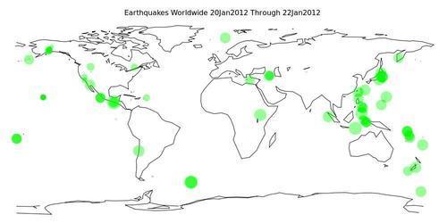
The main purpose of this recipe is to call attention to the fact that gnuplot comes with a very useful datafile called world.dat. This consists of coordinates for a rough outline of the Earth's land masses, as latitude and longitude in the usual degree units. It can be used as a map background for plotting other geographically relevant data. In the following figure, we've overlaid some data on recent earthquake activity:
Getting ready
We've included a copy of the world.dat datafile in case you've mislaid the one that comes with gnuplot. You also need to have the file earthquakes.dat. This contains data from the United States Geological ...
Get gnuplot Cookbook now with the O’Reilly learning platform.
O’Reilly members experience books, live events, courses curated by job role, and more from O’Reilly and nearly 200 top publishers.