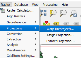
We will now import raster data into GRASS QGIS. But, first, we add the LC08_L1TP_137043_20180410_20180417_01_T1_B2.TIF raster layer into QGIS. We have to ensure that the raster data is in the WGS 84 coordinate reference system, as we have defined WGS84 as the coordinate reference system for our new mapset. We need to reproject the raster into this WGS 84. To do this, we click on Raster in the top menu and then click on Projections, followed by Warp (Reproject), as shown in the following screenshot:

Now, select any output location and write EPSG:4326 in the Target SRS area. Select Near as Resampling method and ...

