Overlaying with Line and Point Feature Classes
When you do an overlay, one of the two feature classes is frequently of the polygon type. The other may be point, line, or, as you saw above, polygon. What does it mean to overlay a polygon feature class and a point feature class? Basically, the change is only the tabular output (although some points may be omitted if they lie outside the scope of all polygons, depending on which command you use).
Overlaying Point Features
Let’s suppose that some point features are parking meters, each of which has a number. See Figure 7-10. In the attribute table, the field Meter_number records this number. See Table 7-4. Also assume that the polygon feature class “A” you examined previously, depicted zones of the city, and it was desired to know which parking meters fell into which zones, so that the income from each meter would go to the correct budget.
| Meter_number |
| 12 |
| 45 |
| 77 |
| 88 |
| 23 |
| 15 |
| 14 |
FIGURE 7-10 Points indicating parking meters
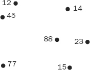
Now if the point feature class (see Figure 7-10) is overlaid on the polygon feature class A (see Figure 7-7), the graphical result of the new point feature class will be the same as Figure 7-10. However, the attribute table of the new point feature class will look like Table 7-5. Figure 7-11 indicates why, showing as it does with the dashed lines, the geographic location “A” of Figure ...
Get Introducing Geographic Information Systems with ArcGIS: A Workbook Approach to Learning GIS, 3rd Edition now with the O’Reilly learning platform.
O’Reilly members experience books, live events, courses curated by job role, and more from O’Reilly and nearly 200 top publishers.

