Direction and Allocation Rasters for Cost Distance
The cost distance calculation is similar to the Euclidean distance calculation in that both can be used to generate direction and allocation rasters. Both calculations allow caps to be placed on the maximum values in the primary rasters they generate. Cost distance differs from Euclidean distance in three major ways:
- It uses a distance-weighting raster.
- It differs in the way in which the direction raster points along the path.
- It calculates the least-cost path rather than the shortest path.
Because the path generated by cost distance goes from cell center to cell center, each cell in the direction raster contains information that indicates to which of the eight neighbors the path goes next. This information is coded according to Figure 8-20.
FIGURE 8-20 Direction code for the next cell in the path
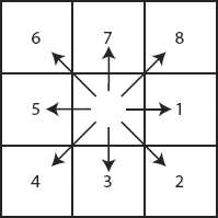
Or, in words:
Get Introducing Geographic Information Systems with ArcGIS: A Workbook Approach to Learning GIS, 3rd Edition now with the O’Reilly learning platform.
O’Reilly members experience books, live events, courses curated by job role, and more from O’Reilly and nearly 200 top publishers.

