What Is Raster Storage and Processing Good For?
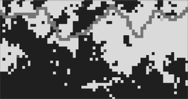
To start with, rasters can be used to solve the same sorts of problems that vectors can. As computers have become more powerful (bigger memories, higher speeds, lower costs, improved compression techniques), rasters are rivaling their vector cousins in solving problems like the Wildcat Boat facility siting problem. Raster methods may suffer, when tightly zoomed in during display, from what is inelegantly called the “jaggies” (see Figure 8-8), where polygonal and linear features are shown in stair-step fashion. This actually may not be a bad thing in many cases, since the precise lines separating polygons usually imply a level of accuracy that does not exist. In human-made phenomena (like parcel boundaries or building footprints), there are such precise lines, but they may not be represented in exactly the right place. In natural phenomena (e.g., the edge of a forest), there is usually little chance that the precise one-dimensional line accurately represents an actual boundary. Here the jagged boundary is a nice reminder that we don’t know precisely where the boundary is—at least partially because there isn’t a precise boundary.
FIGURE 8-8 Raster representation creates jagged lines and polygons

A main objection to using raster methods on the kinds of problems we have used vector methods to solve is that the minimum units for line ...
Get Introducing Geographic Information Systems with ArcGIS: A Workbook Approach to Learning GIS, 3rd Edition now with the O’Reilly learning platform.
O’Reilly members experience books, live events, courses curated by job role, and more from O’Reilly and nearly 200 top publishers.

