Facts about Rasters
Each raster data set must have a name, just as a shapefile or geodatabase feature class must.
Rasters can be, and should be, lodged in a geodatabase. A raster data set may have multiple bands. If so, Spatial Analyst operates on band 1.
Rasters can be either geographic data or image data. We mostly discussed the structure of image data in Chapter 4. Here we will concentrate on geographic data.
A raster should encompass a study site. The raster representing the study area is called a Cartesian matrix, usually with rows parallel to the x-axis of a coordinate system. Columns are parallel to the y-axis.
A geographic raster is (usually) a rectangular matrix of (usually) square cells. Each cell is a member of a row and a member of a column. Almost always all the cells of a given raster are the same size. See Figure 8-1.
FIGURE 8-1 Schematic of a GRID or raster
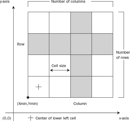
Raster cells may be almost any size. Choosing the cell size that is best for both representing the features of the Earth and for analysis is a science and an art. It is not unusual to have raster composed of hundreds of millions of small cells. If you choose a cell size that is half of what you were previously considering, the new raster will have four times as many cells. This may or may not mean four times the storage requirement (depending on the compression technique used) and four times the processing time. ...
Get Introducing Geographic Information Systems with ArcGIS: A Workbook Approach to Learning GIS, 3rd Edition now with the O’Reilly learning platform.
O’Reilly members experience books, live events, courses curated by job role, and more from O’Reilly and nearly 200 top publishers.

